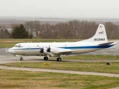
The Lower Fuselage (LF) Radar is an airborne radar system mounted on the lower fuselage of the NOAA P-3 aircraft used by the Hurricane Research Division. It measures radar reflectivity, Doppler velocity, and other radar parameters to characterize tropical storms and precipitation. It operates at 5370 MHz with a horizontal beamwidth of 1.1 degrees. The LF Radar has a maximum unambiguous range of 750 km and a pulse repetition frequency of 200 Hz.

Instrument Details
- Radar
- Earth Science > Spectral/engineering > Radar > Radial Velocity > Mean Radial VelocityEarth Science > Spectral/engineering > Radar > Spectrum WidthEarth Science > Spectral/engineering > Radar > Radar ImageryEarth Science > Spectral/engineering > Radar > Doppler VelocityEarth Science > Spectral/engineering > RadarEarth Science > Spectral/engineering > Radar > Radar Reflectivity
- Full Column Profile
- Variable
- N/A
- 5370 MHz
- Currently unavailable
Currently unavailable
Currently unavailable
NOAA
Currently unavailable
Currently unavailable
data center outside NASA
 P-3 Orion 30 Campaigns · 153 Instruments |  NASA African Monsoon Multidisciplinary Analyses 2006 Cape Verde Islands, Atlantic Ocean 1 Deployment · 22 Data Products
 Convection and Moisture Experiment 1993—2001 US Atlantic coast, Gulf of Mexico, Caribbean 4 Deployments · 70 Data Products
 Tropical Ocean Global Atmosphere - Coupled Ocean Atmosphere Response Experiment 1992—1993 Western Pacific Ocean, Coral Sea 1 Deployment · 1 Data Product
CEPEX Central Equatorial Pacific Experiment 1993 Central Pacific Ocean 1 Deployment · 0 Data Products
CaPE Convection and Precipitation/Electrification Experiment 1991 East-Central Florida 1 Deployment · 0 Data Products
PECAN Plains Elevated Convection at Night 2015 Great Plains, United States 1 Deployment · 0 Data Products
|
Filter data products from this instrument by specific campaigns, platforms, or formats.